为了重振都市基础建设的系统性,强化人们生活与自然的连结;曼谷绿带网利用且绿化了运河道、铁路、高架桥下空地与人行道,将因为缺乏计画性开发、各自成一国的交通要地加以串联,总长达54公里的绿带其中包括28公里的环外与26公里的交叉道路,北临邦苏、南面东接威拍哇丽兰室路、西靠晁飞亚区;曼谷绿带网不论在环境保护、社会或经济面,都将使曼谷成为一永续发展的绿色城市
Bangkok Green Link is a project that create green network within the heart of Bangkok based on the concept of “Revitalize City Infrastructure to Relink Urban Life” linking people and bring back nature to city. As we all know, Bangkok has faced the expansion with lack of planning, creating transportation networks for only automobiles, the clusters of development only along main transportation spots along with bunches of unused land under expressways and along the canal. As a result, these led to the disconnection between important districts and cause other social and environmental issues after. Thereby, this project proposed strategies that regenerate potential elements of the city including canal, railway, space under expressways and sidewalk in order to create connection of public space, district and city together. These 54 km greenways consisted of 28 km of outer ring and 26 km of crossover ways – facing the Bang Sue in the north, Vibhavadi Rangsit road in the east, Rama VI road in the west and Chao Phya Energy zone in the south. Accordingly, Bangkok Green Link will surely create beneficial value to the city – including environmental, social and economic issues, making Bangkok a green, sustainable city.

Bangkok Green Link Masterplan

Space Development Criteria
As Bangkok has been facing problems and challenges in urbanization consecutively, evidencing from the ineffective connection between pathways and transportation system along with the disconnected scattered neighborhood. We developed criteria – choosing 4 types of potential physical areas to develop.
- Canal Bank: It has potential to connect between water and ground transportation
- Walkways: They can be transformed to offer rich experience to passerby, and encourage interaction between people and city
- Space along railways: These idle green spaces can changed to create a more friendly walkways and space for people
- Space under expressways: It can be transformed into public parks in which can offer amount of green space equal to about 4.5 of Lumphini Park

Overall Strategies
Looking at the big picture of this green network, the project aim to create linking of 5 issues:
- Linking Transportation with an effective and a greener way of communing
- Linking District with nodes and public space connection
- Linking People with an interactive event space such as park or pocket park
- Linking Nature with the increasing of greenery
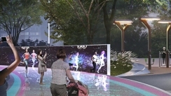
- Linking Technology to fulfill urban lifestyle

This greenery network proposal can be significantly beneficial in several ways.
1. Environmental Benefits
At the end, the project can add up to 10,800 more big trees (about 1.08 million square meters of green space) to the city. According to this, they can also absorb 1,620 tons of Carbon Dioxide and filter 3,580 tons of dust per year. Storm water can be detained and absorbed about 54,000 square meters and temperature can be lowered down for 0.4-3 °C within 30 meters, together with enhancing biodiversity for the civic life.
2. Economic Benefits
In addition, the greenery of the project can increase around 20% of land price and lower down travelling and medical expense as it enhance people to take a walk in civic life. Accessibility to variety of place and activities will accordingly effect on local economic growth.
3. Social Benefits
Thus, this project development will reduce crime as idle spaces had turned into new activity space, and add up the number of inclusive public space for all. Moreover, the increase of walkways and bicycle lanes, along with newly designed half running route that can significantly reduce the usage of automobiles.

Main Link 1 – 10km Expressway Link
10 km Expressway Link is a green walkway under the expressway that connects two prominent city node – Bangsue Transportation hub and Charoenkrung Creative district. The route has also passed through Chatuchak commercial area and Aree residential area. As shown in the diagram, the entire greenway were build up with 6 strips performing different main activities, to fit in appropriately with the surrounding context.
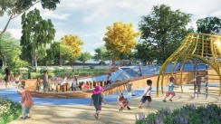
Creative usage is integrated to the existing structure and left-out area, bringing life and interaction to the neighborhood as seen in the transformation of space under highway. Moreover, a part of Activity Strip has been already constructed as a project called “Lan Kila Pat 2”, designed by Shma Soen Company Limited. Similarly, unutilized space among community in turned into homey sport arena and playground for all ages, and kindly done with a participatory process with the community.

Main Link 2 - Sathorn Link - Eco Smart Street Link
This green path has passed through Sathorn, a major road of Bangkok’s CBD, combining technology, ecology and social activity. It aims to reconnect all scattered development and stakeholders together again.
Initially, the street and Sathorn historical canal will be improved for a better quality of live – safety, liveliness and effectiveness. Existing walkways are widened and improved for comfort walking. Cycling lanes are added up along the street with various trees giving nice looking shadings. Accordingly, Sathorn Canal will be cleaned and equipped with plants and tools to treat the water quality along with accessible space for people enjoyment. While looking forward to the final outcome, elevated skywalks will be introduced to underlie the settlement of Grey line monorail system while leaving the least effect to the lively canal. Such elongated space will enable people to do various activities from resting to running, and hopefully learning about nature as it being habitat to birds and insects too.

Main Link 3 - Rail Link – Bike Express Link
This green link turned the area next to the rarely used railway to become a bike express way. It will kindly provide an alternative way of communing passing through various nodes including Makkasan station, Benjakiti Park and Klong Toei area.
Green running and cycling path next to the railway

Main Link 4 - Vipawadee Link – Linear Park and Bike Express Link
Even though Vipawadee road has undergone heavy traffic jam, it has potential to transformed into a linear greenery connecting Din Daeng area to the north part of Bangkok – meeting Jatujak area.
Lively walking and cycling green way transformed along the overlooked canal

Sub Link 1 - Bangson Link – Energy and Urban Farm Link
The unutilized area between elevated expressway and rail line will be turned into a green link, connecting people to various transportation node and neighborhood. Due to the amount of available space, it has a potential to turn into solar farm for green energy production and urban farm for community agriculture.
River banks renovation into livable seating and activities area along with green facilities integration

Sub Link 2 - Jatujak Link – Park Link
3 existing separated parks can be merged to become one continuous enormous green space through this green link. It will also link people between the park area and nearby commercial and transportation hub of Ladprao station.
A fast lane street has been renovated into jogging tracks and bike lanes with car-free conditions. The present unclear drop-off area is then also expanded into an inviting one.

Sub Link 3 - Bangsue Canal Link – Nature Canal Link
This is the green link along Bangsue Canal where natural environment still remained, secluded from fast and chaotic main road. It will potentially connect people living in nearby residential area to the transportation node, Mochit and Bangsue with cheerful recreation spaces.
Bangsue Canal Recreation Space with friendly commuting

Sub Link 4 - Aree Link – Lifestyle Link
This green link fulfill the connection between 2 main city nodes – Dindaeng, residential and local government district, and Aree, lifestyle urban space. The new development comprises of elevated walkways and bike lanes bringing street and main roads to effective livable usage.
Bike lanes, again, are integrating along the highway bridge. Walking path will be widened by replacing parking lots along the road with an extended space for shops and cafes. Sufficient greenery and even attractive hangout space will be added along the walkways. Parking area should be organized sufficiently in the building and existed parking along the road will be replaced with extended walkways, more shop and hangout area.

Sub Link 5 - Victory Monument Link – Interchange and Urban Life Support Link
This green link has passed under the expressway facilitating commuters to various transportation nodes in the area. Social spaces like market or commercial area are also revitalized based on the existing condition to support everyday urban life.
Walkways and existing food market will be reorganized and structurally managed. Spaces beside expressways are reconnected to the canal with the transformation of space into friendly community space.

Sub Link 6 - Saensaep Canal Link – Interconnected Urban and Canal Link
This green link is meant to revitalize area along Saensaep Canal, one of the oldest canals in Bangkok, which serves as an alternative mode of transportation. Blocked up space are opened up to become recreational space as these small spots and various boat stops can transfer people to prominent places in the heart of Bangkok commercial area.
Current disconnection between bridges and piers are solved, creating friendly usage canal bank space. Blocking elements such as walls and fences are replaced with newly designed seating spaces.

Sub Link 7 - Downtown Link – Innovative Exchange Link
As Bangkok’s downtown comprises of diverse land use and building types, this green link will reconnect those variety including Hualampong transit hub, local community, Chulalongkorn University, green public space like Lumpini Park and Benjakiti Park, and even commercial area of One Bangkok and Asoke resulting as a new innovative and knowledge passage.
Main communal bridge located in local community area is renovated to become safer and greener. Unutilized space and structures lying beneath is transformed into various usable space.

Sub Link 8 - Maenam Link – Industrial Art and Nature Link
This green connection revitalize the abandoned rail line near Klong Toey preparing for the new development of Mae Nam Station, situated opposite to Bang Kra Jao, Bangkok ‘s green lungs on the other side of Chao Phraya River. The route aims to transform old industrial area into a new art and museum district.
The prominent railways are renovated combining greenery and industrial style design together.
项目名称 | 曼谷绿带网 | 项目地址 | Bangkok | 项目单位/联系方式 | 游客,隐藏的内容**可见 | | |
|